Hemmed in by luscious green cliffs and constantly covered by clouds that drift down to obscure the epic mountain views, Baños at first seemed to usher in a period of never-ending rain. After getting continuously soaked in the rainforest, Steve and I were eager for a change of pace but unfortunately during our first few days in the mountains we couldn't seem to turn a corner without encountering another downpour. Baños also brought with it an added dose of adventure, as our friend Adam Karmali joined us after traveling through Costa Rica and Colombia.
Of all the places I've been on my travels, Baños is by far the most touristy locale I've ever stumbled across. We couldn't walk through the streets or grab a meal without encountering another gaggle of American students on a chaperoned trip or brief summer getaway. Yet the city is a tourist destination for good reason: Baños is strikingly beautiful and undoubtably Ecuador's adrenaline capitol. Lining all of those green cliffs are a smattering of waterfalls gushing endless amounts of water into the roaring rivers of the valley below and the surrounding area surely has the highest citizen to zipline ratio of anywhere on the continent.
There's a even a waterfall right on the edge of town which deposits its water right next to the city's natural hot springs, a relaxing destination for locals and tourists alike. After a slow first day taking in the town and sampling all the street food we could get our hands on, Steve, Karmali, and I headed over to the hot springs to while away the pains of the Amazon and cause a general ruckus, passing around our fun bottle and running back and forth between the hot and cold tubs.
The following morning we shook off the cobwebs and rented a set of three bikes (unfortunately they didn't have a triple tandem for our threesome) to take in Baños' most popular attraction, La Ruta de Las Cascadas. The main road heading East out of town towards the jungle consists of five waterfalls spread out over 15 kilometers, with steep cliff faces on either side giving way to a roaring river on our right.

The route was about 85% downhill with frequent busses back, which made for a supremely enjoyable ride as we picked up speed on each of the winding downhill turns. Along the way each of the waterfalls was accompanied by popular tourist attractions, including cable cars across the river to the top of the falls and zipline routes everywhere we turned. We rushed through the first few stops to try and avoid the hordes of bussed tourists, but by the fourth waterfall Steve was ready to pull the trigger and get the adrenaline pumping on another level.

Karmali was feeling sketched out about the general lack of safety and infrastructure supporting the zipline apparatus, so I decided to join Steve on the tandem route. Despite the cloudy day, the combination of the speed and the disorienting views made for an exhilarating ride as we flew like birds over the river far below.


We took off again on the bikes and I was still delighting in the rush of the zipline as I tried to cross diagonally over another zipline that was being laid out on the road for construction. Immediately I completely wiped out, sending my bike off to one side and my body off to the other. Before I could even grasp my bearings, I heard the sound of burning rubber and opened my eyes to see Steve’s back tire coming to a screeching halt just a few feet from running me over. If he hadn’t been so aware, I would have taken him down as well on the muddy road.
Eventually I gathered myself and caught my breath enough sufficiently to get on my feet and assess the damage. Through the layer of mud on my knee and elbow some blood had begun to seep through, but after a pit stop to clean things off we were on our way again.
The next waterfall up was the biggest one in Baños, Pailon del Diablo (The Devil's Cauldron). Here the water gushes out of an unseen hole in the rock wall with reckless abandon and tremendous force, soaking everything in the vicinity and continuously shaking the rock walls around it.

The waterfall is also the sight of “The Devil’s Staircase,” a treacherous and slippery set of stairs that takes you right down to the point where you can legitimately feel nature’s power. Not wanting to get everything soaked, we stripped down and set off down the windy stairs to take in the scene.

The following morning we got moving uncharacteristically early and headed over to one of the many tour operators in town to get (wet) suited up and go rafting on the nearby Rio Pastaza, a Class III rapids. While shivering through our wetsuits in the freezing rain we received a brief 10 minute lesson and then were thrown into the river. Immediately, the current took over and we were propelled swiftly downstream. At first the river seemed relatively manageable and we had a great time rolling through the rapids and taking on the massive swells.

At one point a larger rock came out of nowhere to surprise us, sending the boat on a trajectory straight downwards and depositing me overboard right into the river. Whooooops!

Thankfully our safety kayaker quickly came over to my side and hauled me back on board. But our safety wasn’t guaranteed for long: just a few minutes later history repeated itself on a grander scale, chucking 5 of our 7 passengers overboard and igniting a chaotic rescue mission.
Steve and one other guy popped up right behind the boat and were able to grab on, but the other three floaters, including Karmali and myself, quickly ended up getting pulled downstream by the unrelenting current. We found the kayak, but with the three of us hanging on the kayaker was powerless to paddle upstream back towards the boat.

We floated downstream, increasingly aware of the set of shallow, rocky rapids ahead of us. The three of us braced for impact, but it was no use: the rocks hammered our backs, butts, and legs as the boat raced over to pull us on board.
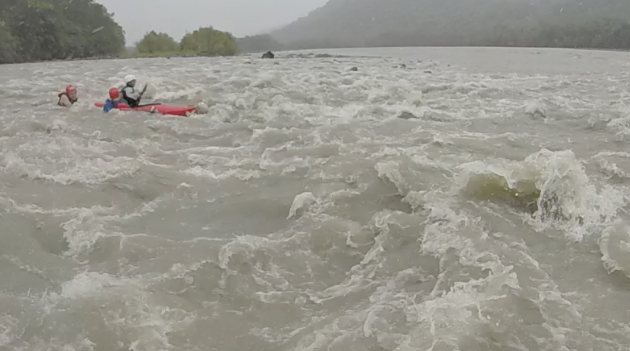
Painfully and with great effort we finally exited the river’s clutches and made it through the rocks, only to be rewarded with another stretch of rapids just ahead. There were plenty of treacherous sections left to navigate, but thankfully we made it through the rest of the ride without anyone else taking an involuntary plunge into the icy river.
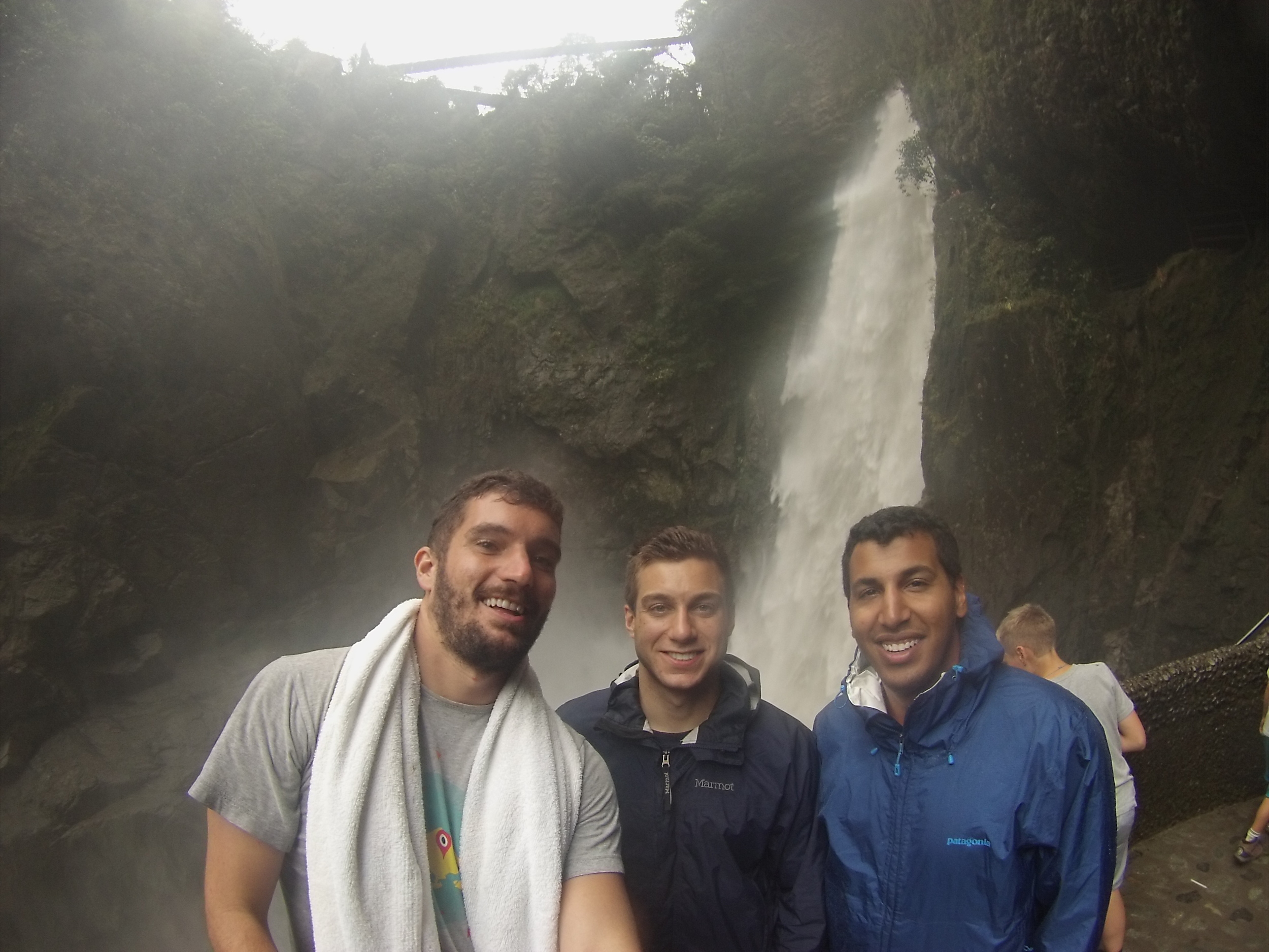
By the time Steve and Karmali departed back to Quito to catch their flights the following day, they were leaving me in Baños with a veritable laundry list of maladies, ranging from the bruises from rafting to an unknown spider bite from the Amazon that was healing suspiciously slowly. Nevertheless, I’m incredibly grateful to have been reunited with old friends in another hemisphere and had the opportunity to share a slice of Ecuadorian adventure with them.
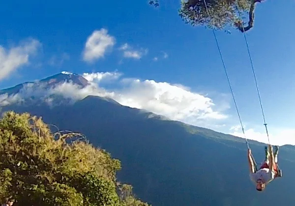
Their departure also ironically brought with it the first rays of sunshine that we had seen since arriving in Baños, so I pounced on the opportunity that afternoon to visit the most touristy attraction of them all: the swing at the end of the world. Set in a treehouse high above the town and overlooking and endless stretch of the valley below, the swing is a cover photo destination and an adrenaline rush all in one. Luckily I arrived just in time to get some shots with the Tungurahua Volcano in the background.


The Avenue of the volcanoes
Ecuador is world-renowned for its stunning complexity. In a country about the size of Arizona, there's the Amazon rainforest, centuries old colonial architecture, and the Galapagos Islands. But the crown jewel in Ecuador just might be "The Avenue of the Volcanoes", a 400KM stretch of parallel mountain ranges from Quito to Cuenca. It consists of massive volcanic peaks surrounding tiny Andean villages including Cotopaxi, the highest active volcano in the world, and Chimobraza, the closest point on Earth to the Sun.
The day after Steve and Karmali left me nursing my injuries in Baños, I set off on the road again, this time to the town of Latacunga, which serves as the jumping off point to explore Cotopaxi and the Quilotoa Lake.
After a week of primarily speaking in English, the bus to Latacunga through me straight back into the proverbial Spanish-speaking fire as I was (not for the first time) dumped unceremoniously on the side of a major highway and told town was a 6 KM walk away. Luckily I was quickly able to decipher that a bus would come by and hopped on a few minutes later. From the terminal in Latacunga I was aided by a good samaritan who brought me towards the town's center and gave me instructions to a guesthouse nearby.
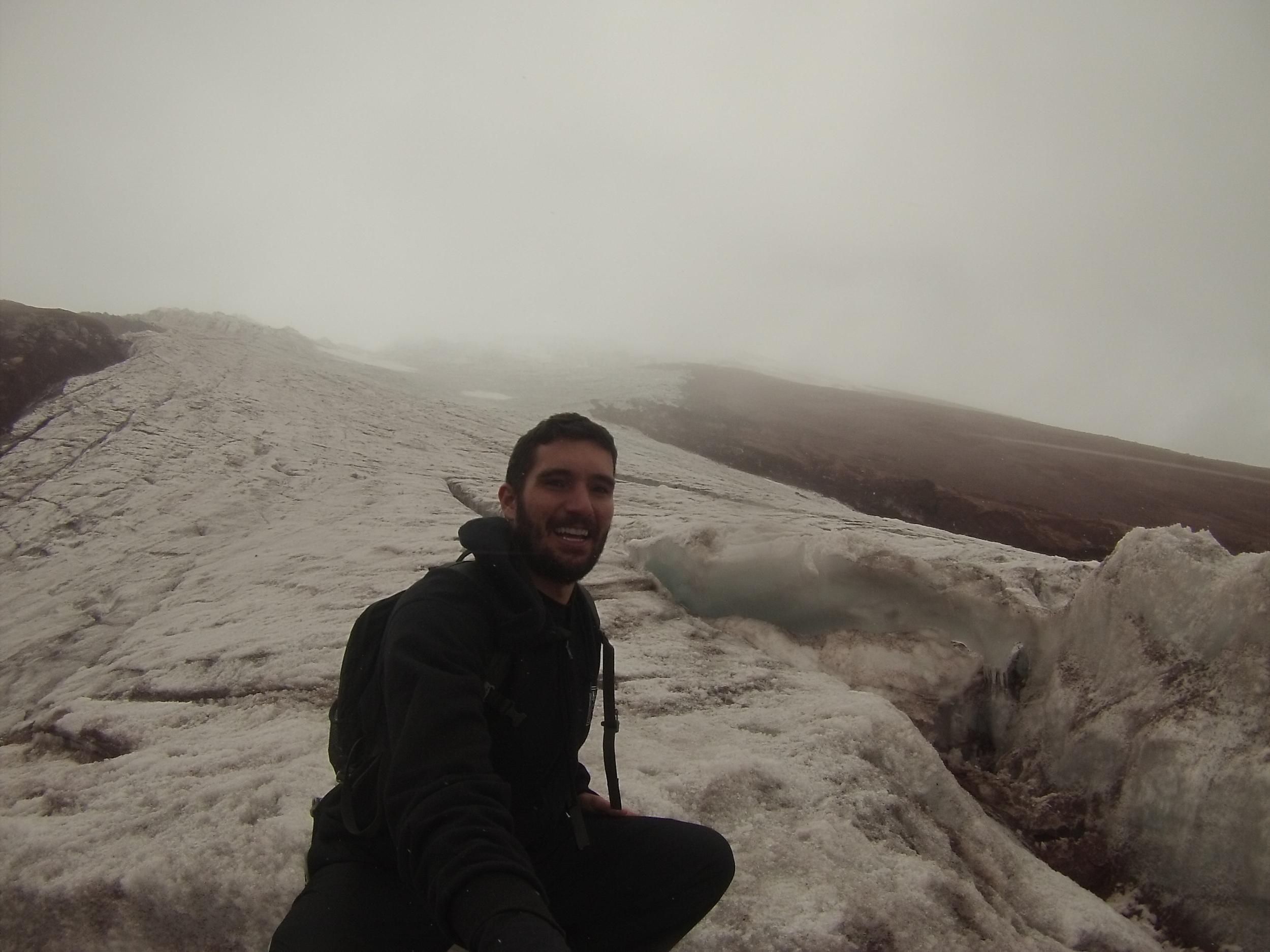
On Wednesday I booked a one day guided tour to Cotopaxi National Park, home to three volcanoes, including its namesake. Cotopaxi Volcano is the most popular summit to attempt in Ecuador and is downright beautiful when seen at a distance due to its perfectly symmetrical cone peak. Unfortunately on this day the entire mountain range was covered in clouds and we didn't even glimpse the Volcano on the way into the park. Steadily, we gained elevation to the main parking lot, where we were immediately met by icy gusts of wind so strong they threatened to knock us over. From there, we climbed the steep trail up to the climber's refuge, which was no easy feet as the elevation was already almost 16,000 feet.

Even through the thick cloud cover, at this point the mountain had clearly made it imposing presence known; every tiny step kept getting harder and steeper. Exposed on the side of the volcano, freezing rain and snow began to materialize out of the clouds, which we were parallel to in elevation by this point.
Intermittently the cloud cover began to break as we trudged further upwards, permitting some ridiculous views of the valley below. The oxidized volcanic rock was a bright red, making it feel like somehow we had been transplanted onto another far less forgiving planet.

Another 200 meters of elevation gain from the refuge is the North Face's glacier. As we first glimpsed its massive form and began to approach, a new sound emerged from the mountain that wasn't the howling wind: rushing water. For as cold as we felt with the wind chill, it was still above freezing and the glacier was melting into a stream on one of the mountain's crevasses.

Over the last century scientists estimate the glacier has already retreated 1000 meters in elevation, causing the surrounding biodiversity dependent on its fresh water to shrink considerably as well. According to a recent study, Cotopaxi's glaciers shrunk by 40% just between 1976 and 2010 and show no sign of halting their demise.
The path up was slippery and treacherous, but stepping on to the glacier and taking in the striking views of its pure white color made for an exhilarating feeling. It was my first time seeing a glacier, but if all goes well with the rest of my trip through South America it certainly won't be my last.


On the way down running towards a warm car seemed easier than walking down the cold slope, so I high tailed it downhill, pretending to go skiing as I careened back and forth the narrow slope.
On Thursday I eschewed the guided tours offered in town and set off on a local bus for the Quilotoa crater, a massive natural lake set around a ring of steep mountains. As the crowded bus wound through the hills, I was treated to a delightful view of farming fields that took on the form of a patchwork quilt and rolling hills as far as the eye could see.
Quilotoa can barely considered a town; it's just a smattering of small shops and hostels without electricity. But just beyond the town's main hill is the view that draws travelers from all over Ecuador: Quilotoa lake.

After taking a few minutes to take in the view and a few deep breaths to grow accustomed to the altitude, I set off for the steep hike around the crater's rugged exterior. Starting off I had no idea what to expect: two french girls at my hostel told me it took them six hours, whereas a group of German guys at Cotopaxi said the previous day they did it in four, and on the ride up a local tour guide mentioned he usually does it in two or three hours.
Immediately upon grabbing a map and departing from the tourism office I came across three French students with the same plan and we agreed to tackle the path together. Their English wasn't very good and my French is non-existant, so we met in the middle and agreed it would be a good opportunity for everyone to practice their Spanish.
Walking around the outer ring at such height we were constantly exposed to the elements and massive gusts of wind rushed through, threatening to steal our balance and send us tumbling down the cliff face. As we circumvented the lake the trail rose and fell, matching each difficult ascent with a steep downhill switchback. The windswept earth made for a slippery and extremely dusty path, but the lake on the interior and the gorgeous hillsides on the exterior made for great accompanying views.

Just after halfway through we approached the steepest part of the trail to the highest elevation point, just shy of 14,000 feet and sufficiently got our butts kicked by the challenging climb, then absolutely destroyed our quads bracing on the descent. As we stumbled up the last few hills and made our way back into town, we were physically depleted and in need of a good long respite in the afternoon sun before heading back to Latacunga.

But if only transportation in the tiny Andean villages of Ecuador was that simple. What follows is the bullet points version of how we ended up getting back:
Someone heard there's a direct bus to Latacunga at 3.....that bus never came.....hopped in the back of a pickup truck back into town....the pickup truck went all around dropping and picking people up on dirt roads while we got our lungs filled with dust sitting in the back....waited for another bus that never came.....haggled with another pickup truck driver for a ride....finally another bus came....this bus never went to Latacunga, it just drove right past the turnoff....got dropped off on the side of the road....hailed down a bus going the other way to Quito.....hopped off as close as we could to Latacunga....sprinted up an on ramp to catch the last bus into town.
Travel: sometimes it's awesome and sometimes it's hard but it's never boring, that's for sure.